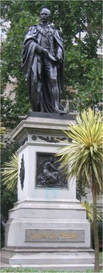
Image right: Sir George Grey
All documents owned by the Balson Holdings Family Trust
Property, Riet Fontein, purchased by George Charles Brisley 1st July 1879 - East Griqualand - signed by Bartle Frere
The Deed of Assignment signed by the Who's Who of South Africa in 1907 acquired by the Balson Holdings Family Trust
The documents listed here were acquired by the Balson Holdings Family Trust from a private hedge fund management and private venture capital business based in Geneva. The documents are each worth several thousand US$.

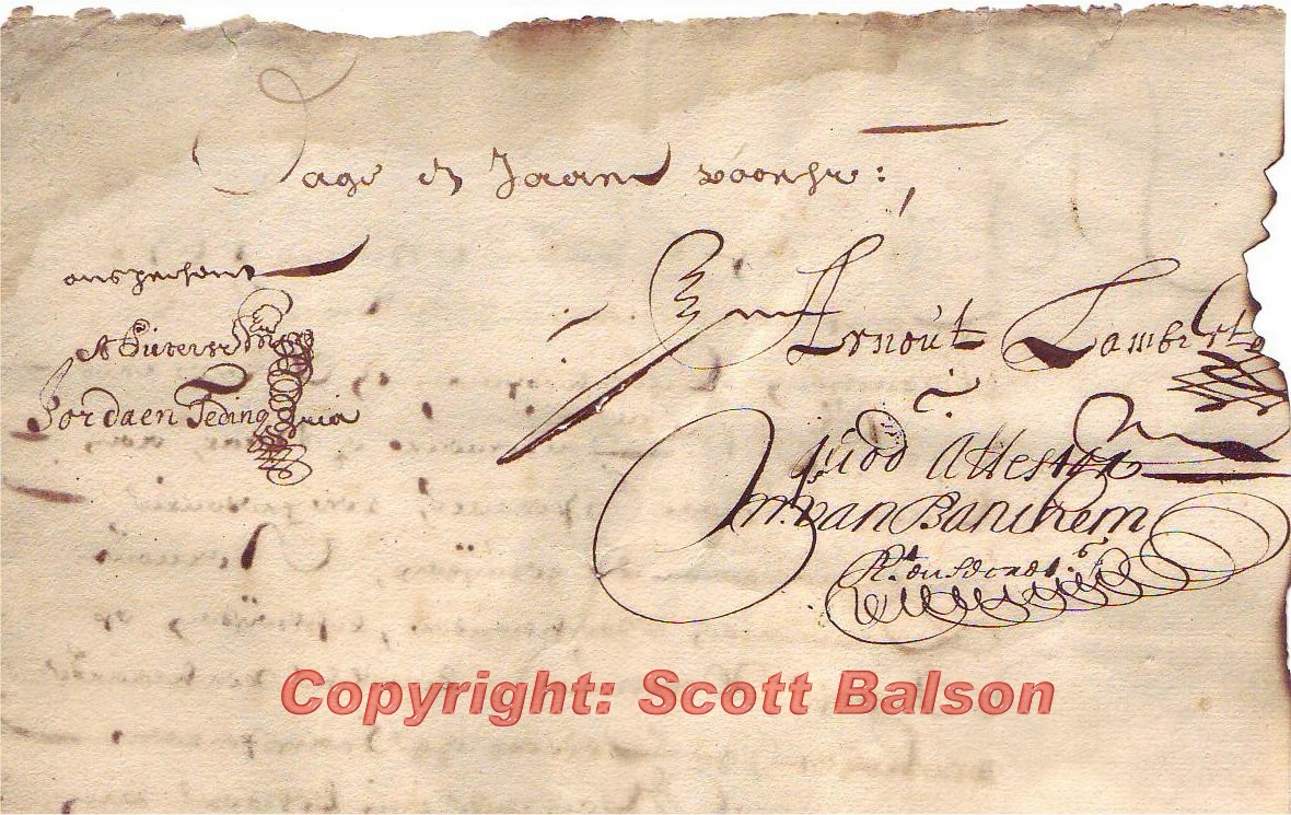
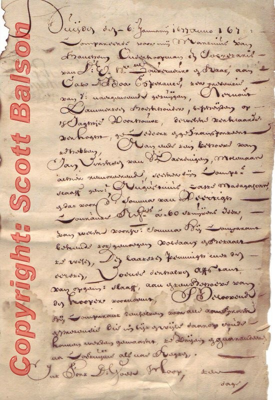
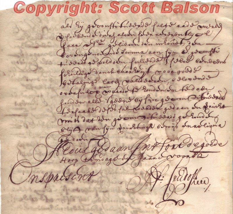
One of the very first land grant issued at the Cape of Good Hope (COGH), dated the 6th January 1677 (just 12 years after the first settlers arrived at the COGH in 1665). This manuscript document issued by van Banitan (see images below), as Secretary is also signed by two members of the Council of Policy. This grant consists of two back to back pages with a watermark of the Dutch East Company (VOC). This land had been confiscated from the Hottentots in Cape Town not long before and was of less than 20 land titles issued in South Africa at this time.
There were no revenues on this document as the VOC Directorate had made a decision not to allocate land to officials of the company. However by the time Wilhem van der Stel arrived to take up his post as Governor of the COGH he found that most key officials owned the land on which they farmed contrary to the VOC directorate's policy and had been corruptly issued with land grants, the new landowner often been an official party to the document.
  |
| English translation summary:
This is a deed for landownership, regarding hunting grounds in the Cape. The grounds are transported (handed over) from one man to another, signed by a witness and sealed by the proper authorities, in God's name on January 6th 1677. The grounds are called Hoontrouwe and assigned in accordance of Law as they were in East Madagascar. The sum of sixty stuivers (5 cent piece) has to be paid on acceptance date. There is a guarantee and an appendix.
|
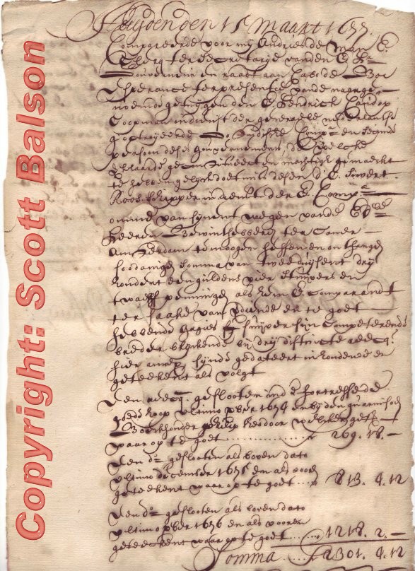
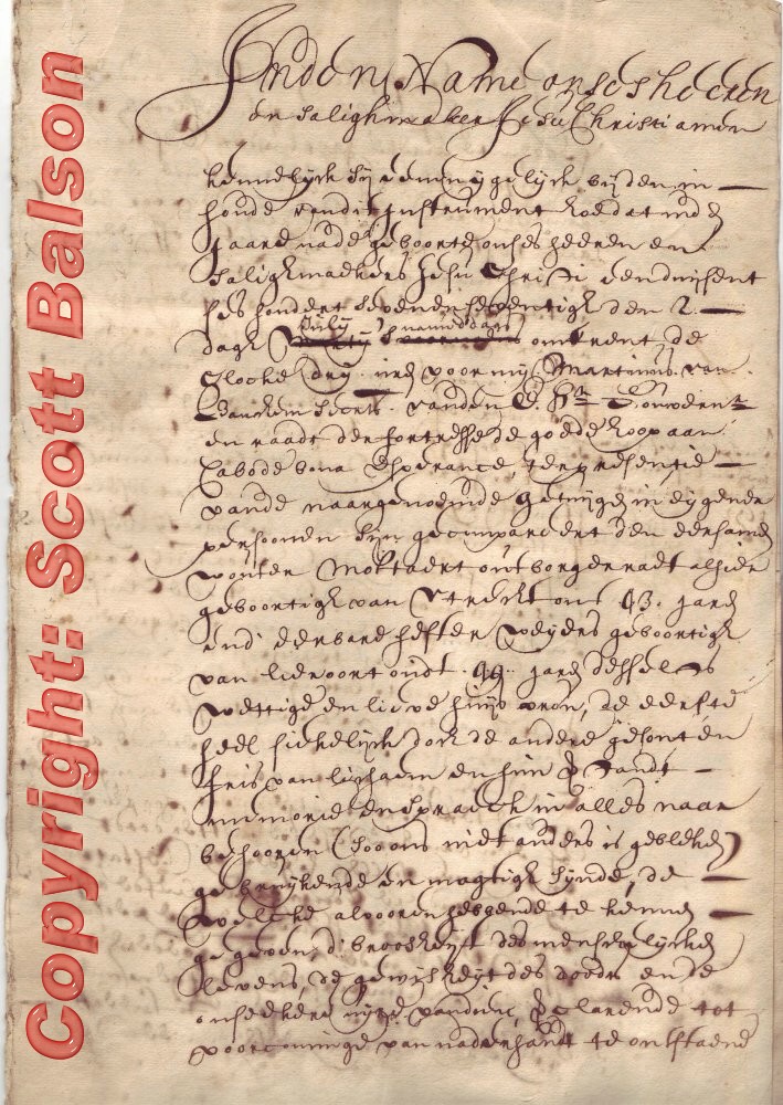
1677 debenture dated 15 March 1677 and issued and signed by future VOC Governor Henrik Crudorp (June 1678 to Oct 12 , 1679) in his capacity as a member of the Council of Policy.
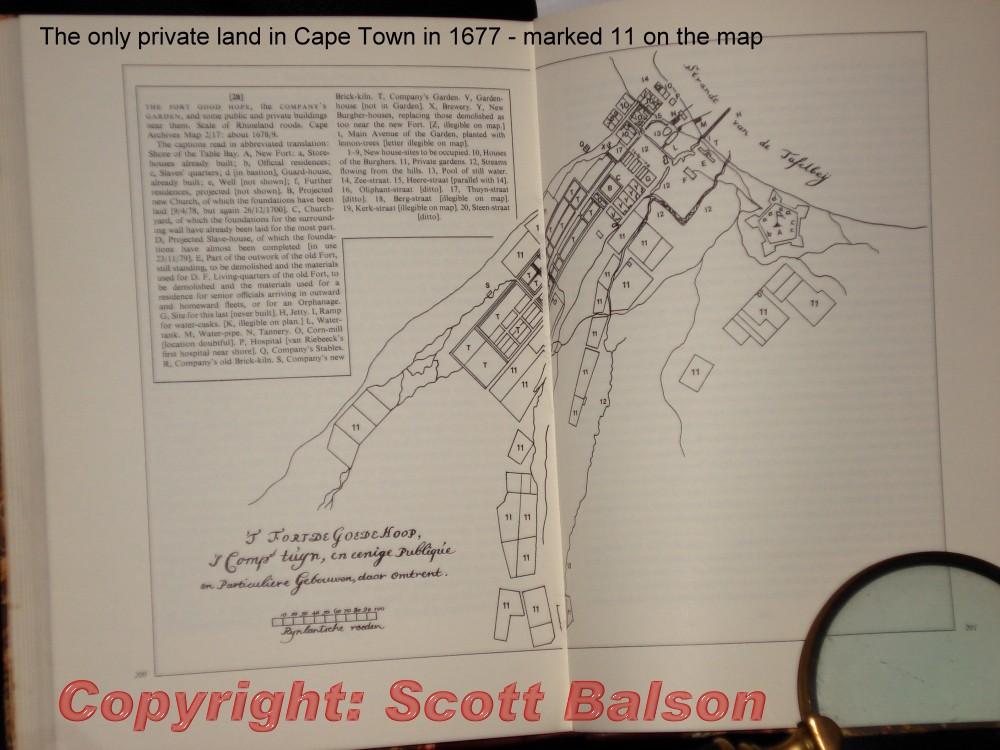
Image Right: pg 200-201 "Cape Good Hope" R Raven-Hart (1971) - this image is of the early settlement of the Cape in 1677 and notes that there were less than 20 private gardens at this time. The related article taken from diary notes by Georg Meister gives a fascinating insight into the lives of the early settlers.
This was a period of considerable conflict with the VOC Headquarters who specifically gave instructions that individual land grants were not to be issued to Individuals and that farming should be on a communal basis. They never changed their policy but Governor Simon van der Stel (1691 to 1699) was able to significantly increase the food output by introducing cattle, sheep and fowls (chickens) and show that Individuals farming for themselves were more productive than communal farming.. Between 1652 when Jan Van Riebeck became the first Govermor (for 10 years) the VOC appointed and dismissed 7 Governors before Simon Van der Stel (who was known for his diplomacy with the head office). All the Governors before van der Stel, including Crudorp, were dismissed for violating their policy and issuing land grants to individuals. This land grant is signed by Van Breugel in his capacity as a member of the Council of Policy that ran the beauracracy of the Cape of Good Hope.
In 1711 the VOC finally relented and started issuing VOC Colourless Revenues on land titles (see below).
 |
 |
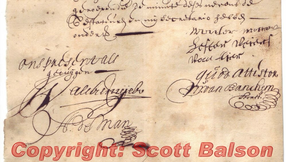 1680 - Dutch East India Company Debenture
Manuscript
1680 - Dutch East India Company Debenture
Manuscript
This seven page long debenture document is signed by two members of the Council of Policy in Cape Town including A de Man and M van Banitan as Secretary.
The manuscript is signed by a couple of Hottentot Chiefs, who's basic signatures can be seen at the top of the right of the scan to the right. It is most probable that this document is the original deed to lands around Cape Town "sold" by the Hottentots to the Dutch East India Company for the sum of 8000 Rix Dollars (as noted in the document).
This is a very rare document.
 1715 COGH Land Grant w/12 stuiver VOC
revenue
1715 COGH Land Grant w/12 stuiver VOC
revenue
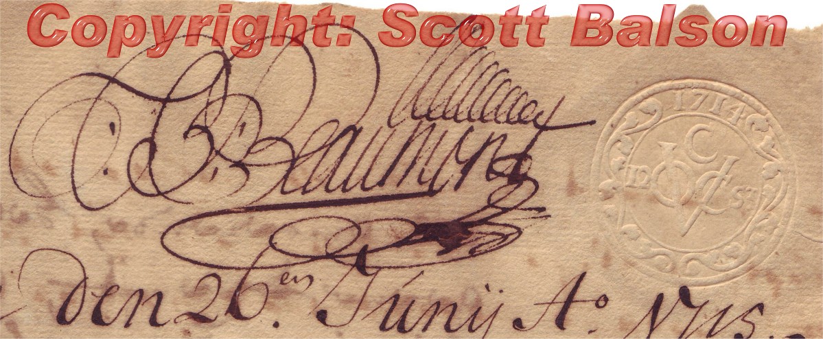
Complete manuscript document inscribed on both sides with a watermarked page being a confirmation of debt to the VOC dated 26th June 1715.
The document has a very clear 12 stuiver colourless VOC Revenue stamp cancelled by the Fiscal Beaumont (seen right).
Issued by van der Meer Petersoon in his capacity as first secretary to the Council of Policy and witnessed by H. Swellengrebel (later Governor) and D. Leumes members of the Council of Policy.
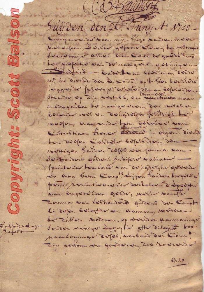 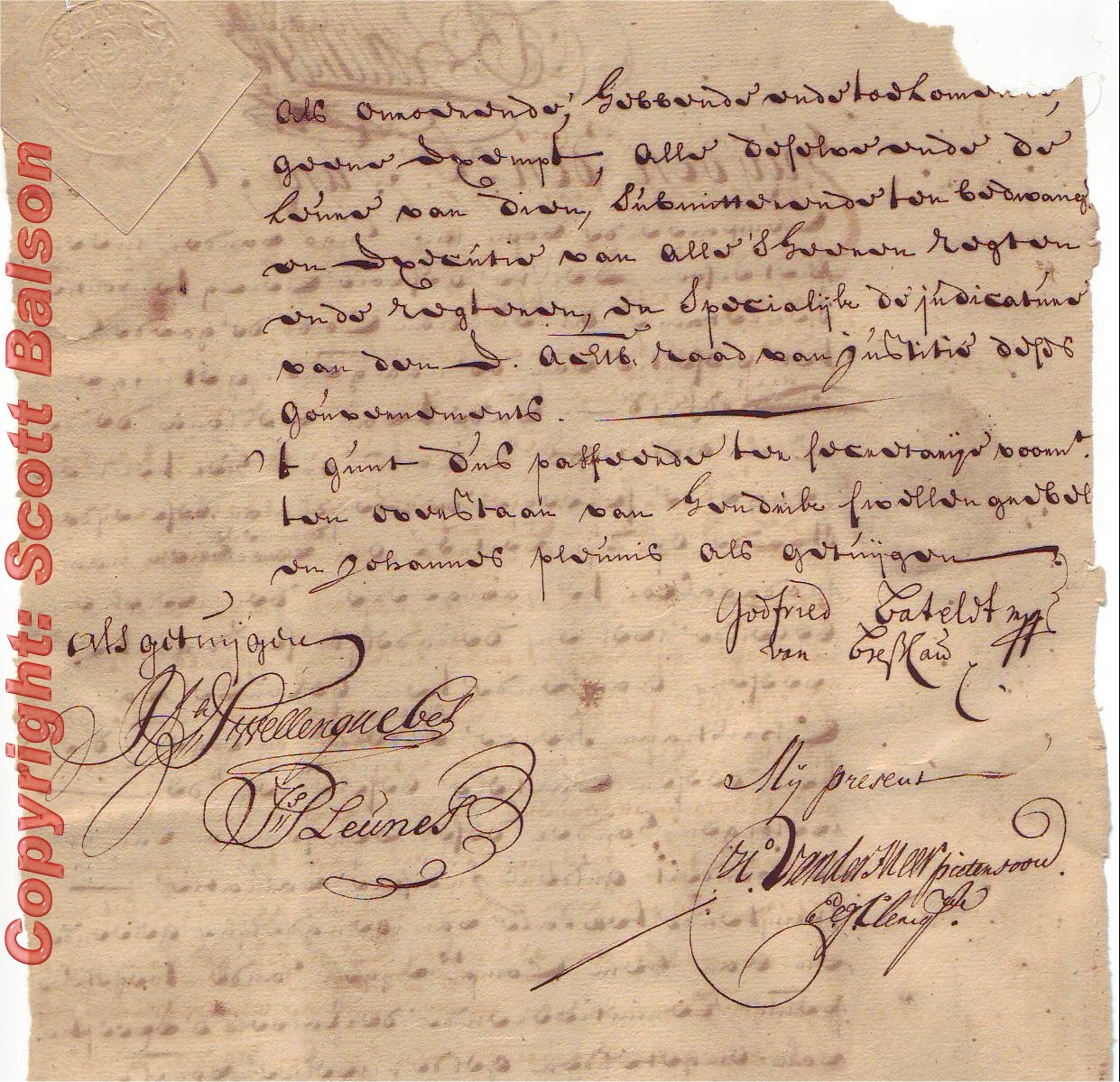 |
| Translation
A ship's Captain in the service of the company (VOC) and his immediate departure on the ship de Zwijdsman, in the vicinity of Cape Town who is sailing to Madagascar. Then the legal owner of this ship is to pay 600 guilders to the company as he has borrowed the money from them. He shall pay upon first demand and shall be held to this contract with the VOC |
1718 - Dutch East India Company
Cape of Good Hope complete manuscript document on two sides of a watermarked (not rust) page being a very rare land grant dated 29th June 1718. Issued by Adriaan can Kervel in his capacity as Secretary (he was later Governor of the Cape) and two other members of the Council of Policy (Privy Council) of COGH) including Willem van Flaack, generally regarded as the father of South African Sheep Farming. The document is complete with uncracked "CDG Hope" seal and 24 Stuiver VOC (Dutch East India Company) Colour Less Revenue (which Sherwood's revised list valued at £80 in 1986 - C3a). The document is cancelled by the fiscal and has an addendum (codicil) in the left hand margin (which was unusual and rare) signed by future Governor Swellenfrebel and two other members of the Council of Policy.
It is difficult to estimate what the document of revenue and seal is worth today but a figure of US$1000 to US$1800 is an indication.
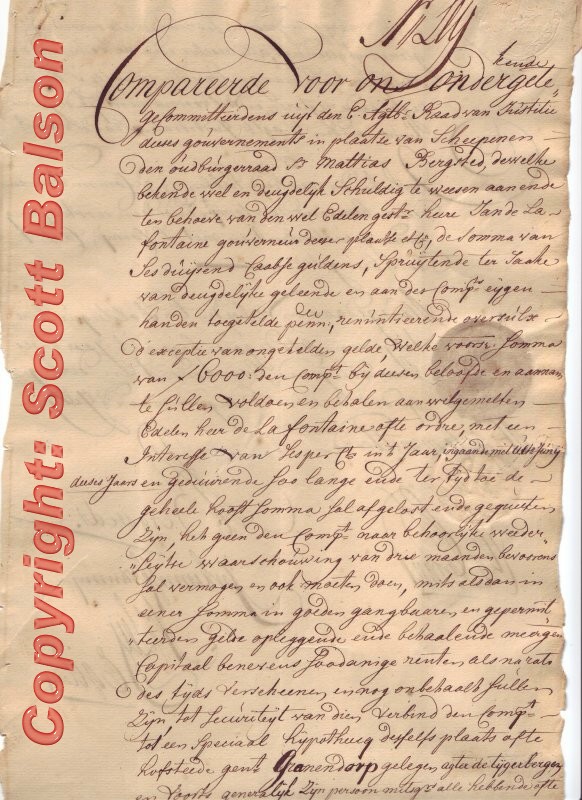
1730 - Dutch East India Company:
Cape of Good Hope complete manuscript document on two sides of a watermarked (not rust) page being a very rare land grant dated 10 July 1730. Issued by members of the Council of Policy (Privy Council) and signed by Nicholas Leij and two members of the Council of Policy with complete "CDG Hope" seal (seen right) and 24 Stuiver VOC (Dutch East India Company) Colour Less Revenue (which Sherwood's revised list valued at £80 in 1986 - C5).
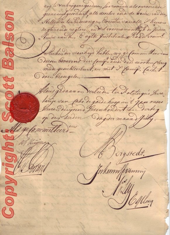
This land grant (see images below) was originally issued by Olaf Martini Berg and other members of the Privy Council and the Revenue also cancelled by Berg. This land grant has an endorsement by Berg, the Secretary of the Council of Policy (employees basically held office on a rotating basis determined by the Dutch East Company in the Netherlands). The endorsement is dated 23rd September 1750 and the transfer of the property is made to a descendent of Olaf Berg - nepotism was rife at this time. Berg was acting Fiscal and an Auctioneer later in his life. He died in November 1785.
 |
 |
 |
| English translation of document
above:
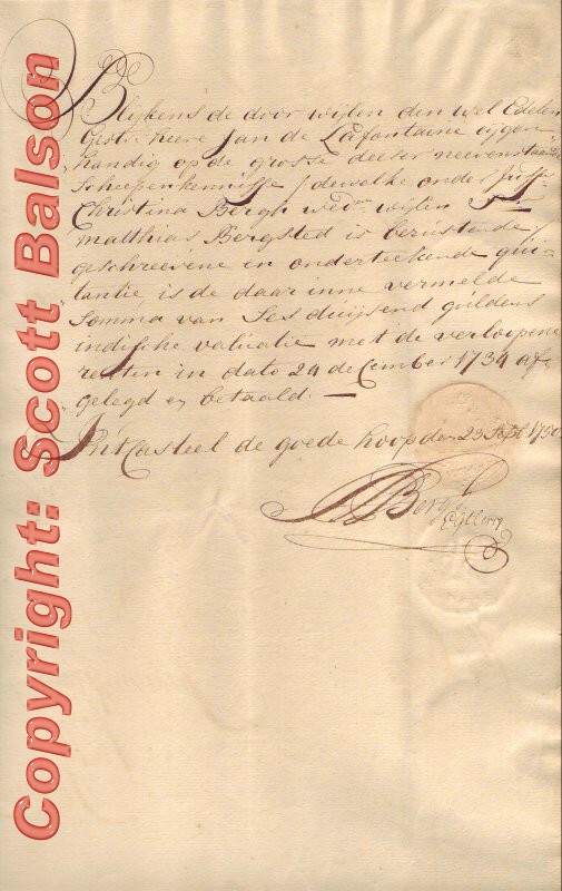
As appears from shipsknowledge in his own hand, deceased esquire Jan de Lafontaine, has bequeathed the old miss Christina Bergh, widow to the late J. Matthias Bergsted in this written and signed note of remittance, the sum of sixthousand guilders in various currencies, including expired interest, dated 24Th of December 1734 In Kasteel de Goede Hoop, the 23rd of September 1750
|
Land grants from this period are very rare in private hands especially in near pristine condition like this. The rarity is enhanced by later endorsements relating to the original land grant - signed 20 years later.
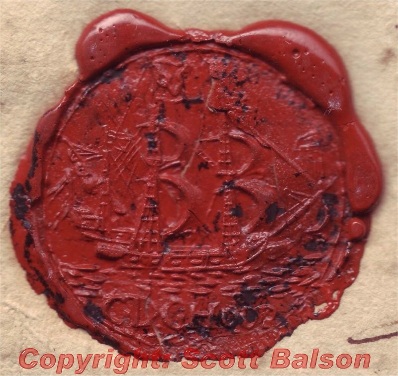
There were approximately 15 seals in use over the entire VOC period. Few seals are not cracked. This is an extremely rare and unique piece of Africana and early Cape of Good Hope History. (The CDGH at the bottom of the seal stands for "Cabo De Goede Hoop" - the Dutch for Cape of Good Hope.)
The only catalogue that has a listing of the VOC period colourless embossed revenue stamps, The Catalogue of South African Revenues, was published by the late C.E. Sherwood of 105 Marford Crescent , Sale, Cheshire, U.K. and is based on a catalogue by Walter Morley who was the first to list these Cape of Good Hope VOC Revenue Stamps in 1910. Sherwoods Catalogue in 1967 compiled a revised list by the late Leonard J. Dodd.
This document was originally sold by Ralph Putzel Auctions (author of the 4 volume The Encyclopedia of South African Post Offices and Postal Agencies and its sister publication The Postmarks of South West Africa - Namibia).
Prior to the Issue of British Revenue stamps in the Colony of the Cape of Good Hope, the revenue stamps in use were those issued by the Dutch East India Company, The stamps were embossed in circular format with the Company's VOC seal in the centre, above which there is a "C" to indicate their use at the Kaap de Goede Hoop as it was then known. At the top, various dates are seen of which the earliest is 1711. The values issued were 6,12, 24,36,48 stuivers and 1 1/2 ,2,3, 4,5,6,8,10,12,15,20,39,40 and 50 Rix Dollars. They were embossed on white or azure laid paper and were in use as late as 1849 and all through the French Occupation of the Cape of Good Hope.(1798 to 1806).
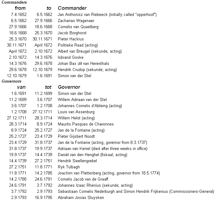
The Council of Policy [Raad van Politie; politie means ‘management’] being the highest authority at the Cape of Good Hope settlement, was subject to the instructions of the Lords Seventeen (directors of the VOC in the Netherlands) and the Governor-General and Council of India in Batavia, as well as the legislature stipulated in the “Statuten van Batavia” [Statutes of Batavia] (1648). The Council consisted of the functionaries who were responsible for ruling the Company’s settlement, namely the “opperhoofd” [head] of the settlement, his secunde, administrative officials (e.g. accountant, warehouseman, cellar-master and harbour-master), the military commander of the garrison, and the fiscal who was responsible for maintaining law and order. The Council’s secretary (also called “geheimschrijver” [confidential secretary]) had no vote, unless he had at the same time been promoted to Councillor.
When there were ships in Table Bay , the captains and other high-ranking officials of the fleet also had seats on the Council. These sessions were referred to as sessions of the Broad Council. The chairman at meetings of the Broad Council was not necessarily the commander/governor himself, since he had to relinquish his chair to his senior in rank in the service, usually a commissioner who had instructions to compile a report on affairs at the Cape.
The VOC officials carried out a large number of functions. There were actually three groups of hierarchies: from soldier to general, from young sailor to sea captain, and from scribe to governor-general. The Company also distinguished between various ranks referring to a combination of function, salary and status. For example, the senior merchant Jan van Riebeeck was head of the Cape settlement, and his rank as senior merchant indicated his place in the Company’s commercial/administrative hierarchy and salary category. His promotion to commander implied more status but neither more authority nor a higher salary. From 1691 the title of the head of the Cape settlement was that of Governor.
In 1676 Commissioner Nicolaes Verburg decided that the Council of Policy, in addition to the commander as the highest official, should consist of six councillors/council members. In 1685 Commissioner Hendrik Adriaan van Reede tot Drakenstein determined that the number of members would be increased to eight. In the same year a separation was made between the Council of Policy and the Court of Justice when it was decided that the Council of Policy would function as the Court of Justice. Whenever a case of a burgher was heard by the Court of Justice, two burgher councillors had a seat in this court.
The Council of Policy met quite frequently. It mostly depended on the commander, as convener, how regularly and how many meetings would be held. Some chairmen convened the Council once a week, while others only convened a meeting when urgent matters necessitated a meeting. Sometimes the agenda was so long that the meeting, which commenced in the morning, also had afternoon and evening sessions. It could even happen that the previous day’s sessions continued the following day. In case of an unforeseen crisis the Council would meet on a Sunday, public holy day or day of festivity.
All letters from the Lords Seventeen and the High Government of Batavia had to be opened, read and discussed at the Council meetings. The letters of response were written by the Council and signed by all the members. All written work was done under the Council’s supervision. Not only had copies of the long letters to be sent to the authorities in Amsterdam and Batavia , but also copies of the journals, resolutions, “placcaten” [proclamations] and instructions. Court proceedings, contracts and reports also had to be written up. The officials were responsible for collecting taxes and had to supervise outposts, warehouses, leases, as well as supplying victuals to ships, officials and the hospital. They also had to protect the settlement against possible attacks from the interior or from the sea. The Council of Policy discussed all these tasks and the Councillors often delegated the responsibilities to other officials
During the 143 years of Dutch government at the Cape the term of office of the official who headed the government of the colony was sometimes very brief, while others remained in power for a long period.
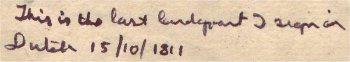
 1811 - British Colonial Rule - unique title deed expressing
the Governor's outrage
1811 - British Colonial Rule - unique title deed expressing
the Governor's outrage
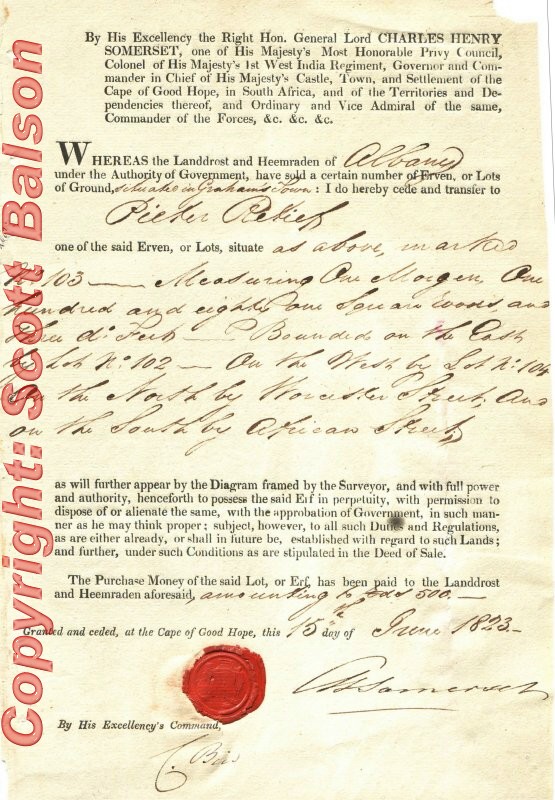
An historic and unique document.
The large Iron Ore Saldanna Bay Harbour is situated on the land given under this grant to Jabobus Retief, the oldest brother of Piet Retief, who led the Great Trek with Gert Maritz. The document, dated 15th October 1811, is signed by Lieutenant General Sir John Francis Cradock (Governor of Cape of Good Hope Sept 6 1811 to 6th April 1814). Cradock was brought out to the COGH to deal with one of the many Xhosa uprisings.
The 100 morgen land allocation was significantly large and was situated in the centre of Saldana Bay where the massive Saldana Bay Harbour iron ore development is now located.
Cradock was known for his temper and this is the last land grant he signed in Dutch and he put these feelings in writing. He wrote in ink: This is the last landgrant I will sign in Dutch
Soon after he had Dutch Fiscal documents duplicated with English translations
and replaced the Dutch Fiscal Bureacrats who had been responsible for the
Dutch documents. Land grants signed after this were huge, with the documents
being preprinted with Dutch on the one side and a translation into English
on the other.
The South African town of Cradock is named after him. He was elevated to 1st Baron Howden on Sptember 14th. 1831 and the titled passed to his son's on his death.
Translation of the document:
By his Excellency Lt. General Sir John Francis Cradock, Knight of the noblest Order of the Bath and the Crescent, Colonel to his Majesties 43rd reg. infantry, Governor and Commander in Chief of his Majesties Castle, City and Colony the Cape of Good Hope in South Africa, and Vice Admiral, Commander of the Troops etc. etc. etc.
Is given under his grant in everlasting hereditary tenure to
Jacobus Retief
certain piece of Land, situated in the Cape District Saldanna Bay annex Delftse Leening (not entirely sure of this) placed between IJzervarkensrugge and the corners of the Bay and in size
100 Morgen
That Jacobus Retief in fact on expiration of every twelfth month counting from this day on, will pay or have paid to the Receiver General of Income (revenue) of Farming fields (land)
the sum of twenty five rixdollars and will be held to the existing laws of this colony in taking care of properly sealing the limits and that the land is brought in such state of cultivation as suited for that purpose, and such within the time limit of the first three years ; should not be transferred until the expiration of this period and also that this land presently released will fall subject to all such impositions and rights, already made or will be in due course on such farming fields.
Therefore granted under my hand and seal in the castle De Goede Hoop, October 15th, 1811
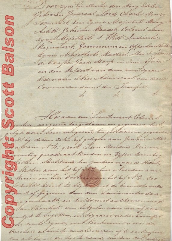
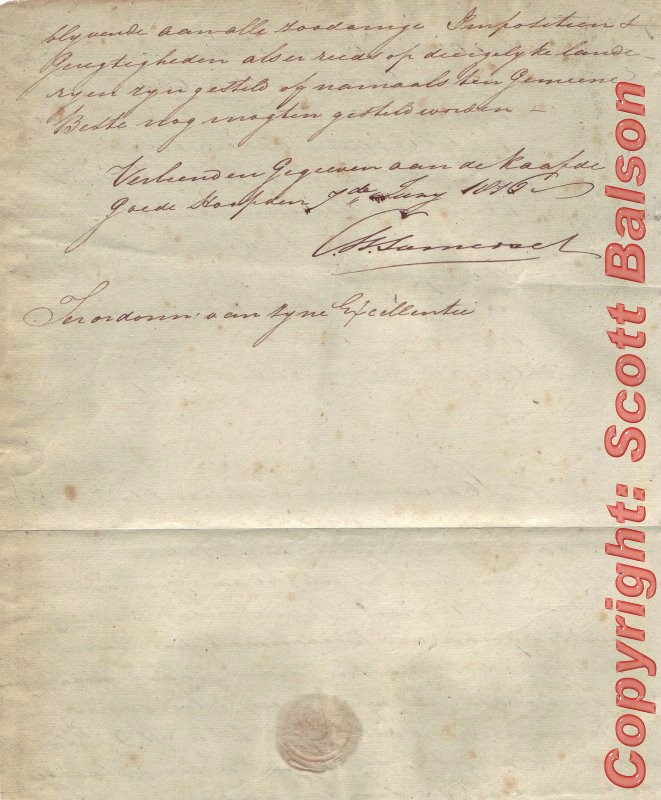
1816 - British Colonial Rule - title deed in Dutch granted to Lieutenant Colonel Prentice
 This Dutch
landgrant was written by Pieter Gerhard Brink on behalf of Governor Lord
Charles Somerset. The Governor refers to the deed in his diary which was
for the open block of land on the Table Mountain side of what is today Green
Market Square, a cobbled square in the centre of Cape Town and a bustling
antique and bric brac market on weekends.
This Dutch
landgrant was written by Pieter Gerhard Brink on behalf of Governor Lord
Charles Somerset. The Governor refers to the deed in his diary which was
for the open block of land on the Table Mountain side of what is today Green
Market Square, a cobbled square in the centre of Cape Town and a bustling
antique and bric brac market on weekends.
Image Right: Picture taken of the historic buildings bordering Green Market Square.
The buildings erected on this land grant are national Monuments today. They
were built and are today furnished in the style of the early 19th Century.
Somerset like his predecesor Cradock did not want any future landgrants to
be in Dutch. He was appointed Governor on 6th April 1814 and resigned on
5th March 1826. He ordered preprinted landgrants with his elaborate title
in mid 1815 from the United Kingdom and is not known to have signed any
other Dutch titles. Somerset made an exception with this one as it was
in favour Lieutenant Colonel Prentice who had served with him in the Napoleonic
Wars. Prentice had come to the Cape with Somerset as a financial administrative
assistant - establishing a bank at the Cape. This land grant was for the
one of the last unallocated lots (originally designated as a troop barrack)
in the center of Cape Town.
Prentice built luxury living quarters in what became known as Cape Architecture Style and a duplicate building that became the Cape Colony first bank and Stock Exchange. Brink while fluent in both English and his home language of Dutch wrote the landgrant in Dutch and from a synopsis given to him by Governor Lord Charles Somerset. Prentice left a large area in front of the two buildings he erected for wagons bringing customers to his Bank.
This later became known as Green Market Square. As the constant wagon traffic severely damaged the roads in the vicinity he had all the roads leading to Green Market Square cobbled in stone (see image right) - a distinguishing feature that remains today. Prentice also established the first Theatre in Cape Town which he financed with the first shares issued in the Cape Colony. The theatre later became the Custom House.
 1823 - British Colonial Rule
- title deed granted to Pieter Retief
1823 - British Colonial Rule
- title deed granted to Pieter Retief
Pieter Retief was the recipient of this land title at Grahamstown and later a leader of the Voortrekkers whose great trek took them from the Cape north through Griqua territory on their way to Natal.
The title deed is signed by Lord Charles Henry Somerset, Governor of the Cape
The capital of Natal, Pietermaritzburg is named after him and Gerrit Maritz - the other Voortrekker leader.
Pieter Retief was murdered by the Zulus near the Drakensberg before the famous battle of Bloodriver.
More on Pieter Retief at this link
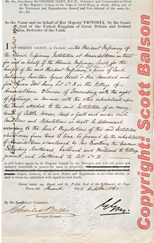
 1860 - British Colonial Rule
- title deed Division of Fraserburg
1860 - British Colonial Rule
- title deed Division of Fraserburg
Landgrant signed on 2nd October 1860 by Sir George Grey, K.c.B., Governor and Commander in Chief of Her Majesty's Colony of the Cape of Good Hope, in South Africa and the Territories and Dependencies thereof and Vice Admiral.
Also signed by the Surveyor General Charles Bell, better known as the designer of the Cape of Good Hope Triangle Stamps.
The deed is in favour of Ian Plefsie for about 1250 sq roods (over 300 acres) in the village of Amandelboom (now called Williston), in the Division of Fraserburg due north of Sutherland in the dry and hot Roggeveld district of the northern Cape. Amandelboom, meaning almond tree, was established in 1845 and started as a Rhenish Mission Station by Pastor Heinrich Lutz at a fountain near the Zak or Sak River. The name originates from the almond tree under which Pastor Lutz first pitched his tent. The Mission became home to many wandering nomads in this area and it was only in 1883 that a village developed around this station. Amandelboom was renamed Williston in 1919 after a former British Cape Colonial secretary, Colonel Hampden Willis. Historically this hilly setting was used by religious choral groups, hence the name "Singkoppe" - the hills of song.
There is a colourless embossed seal of the Governor of the Cape of Good Hope at the bottom of the document and the watermark of the Cape of Good Hope.
It was Sir George Grey who authorised the move of the Griquas from Philippolis to No Mans Land / East Griqualand
 1860 - British Colonial Rule - title deed Amandelsboom
- Almond Tree - (19,000 morgan)
1860 - British Colonial Rule - title deed Amandelsboom
- Almond Tree - (19,000 morgan)
This preprinted land grant signed on 3rd October 1860 by Sir George Grey and also by the Surveyor General Charles Bell bears Grey's clear large colourless Seal of Office imbetween the two signatures. The one line endorsement (seen right) confirms that the land was returned to the Government in 1877 when the Rhenish Mission at Amandelboom closed.
The Rhenish Mission (Catholic Church) under Johann Heinrich Lutz, a German Missionary, established a farm at Amandelboom (from 1845-75) for their own subsistence and to hold cattle, horses, sheep and goats in the area long before taking title in 1860. It had by then become the Village of Amandelboom in the Division of Fraserburg. Lutz taught at Amandelboom (now called Williston) at this time when Klaas Lucas, the chief of the Koranna people, invited him to come to !Oama to teach the people to read and write.
These Catholic Missionaries were technically operating without authorisation but successfully converted the entire Black population they encountered to Christianity although few joined the established Churches. Most joined Zionist Churches with lots of evangelism and song rather than the rigid prayer book of the Catholic, Presbiterian, Anglican and Methodist Churches.
The preprinted land grant starts By His Excellency Sir George Grey K.C.B., Governor and Commander-in-Chief of Her Majesty's Colony of the Cape of Good Hope in South Africa and of the Territories and Dependencies thereof and Vice-Admiral of the same etc etc. All except one of Grey's land grants were on the preprinted form which does not have a watermark. This landgrant reflects the first appropriation of land per property law in South Africa - an act which is still challenged in the courts today.
It was Sir George Grey who authorised the move of the Griquas from Philippolis to No Mans Land / East Griqualand
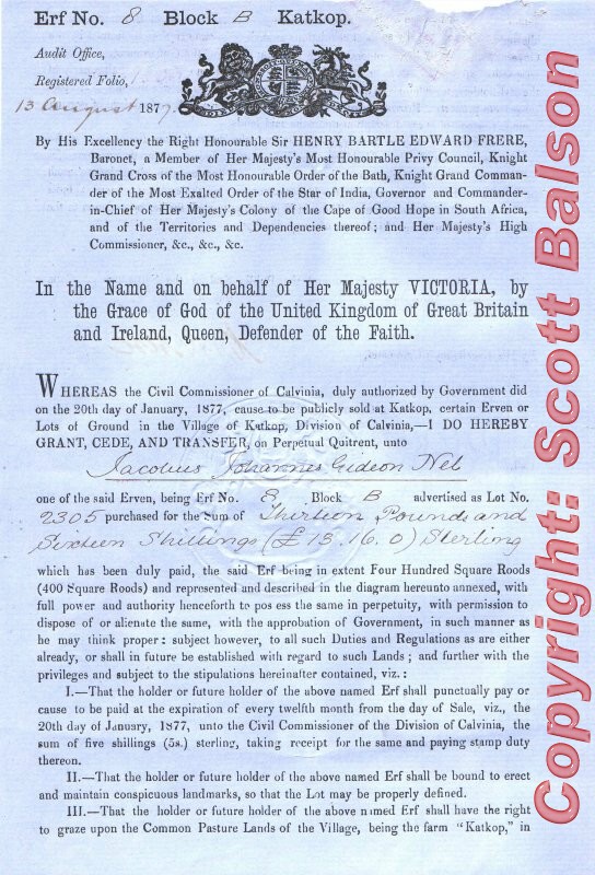 1877 - British Colonial Rule - title deed Village of
Katkop - Division of Calvinia (Eastern Cape)
1877 - British Colonial Rule - title deed Village of
Katkop - Division of Calvinia (Eastern Cape)
Land grant dated 7th August 1877 in favour of Jacobus Johannes Gideon Nel in the Village of Katkop in the Division of Calvinia in the Eastern Cape.
It has his excellent colourless embossed large seal of office clearly visible from a meter away and also signed by Andries Schmidt the Surveyor General. The subdivision of the abandoned farm of Katkop followed an earlier Xhosa raid that killed all the inhabitants. The allocation of land was based on conditions which are listed on the preprinted land grant . The deed has a large emblem of a lion and Unicorn on either side of a shield topped by a crown similar to his own seal of office. It starts "By His excellency the Right Honourable Sir Henry Bartle Edward Frere, Baronet, a Member of Her Majesty's Most Honourable Privy Council, Knight Grand Cross of the Most Honourable Order of the Bath, Knight Grand Commander of the Most Exalted Order of the Star of India, Governor and Commander -in Chief of Her Majesty's Colony of the Cape of Good Hope in South Adrica, and of the Territories and dependencies threof; and Her Majesty's High Comissioner"
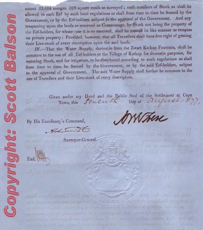 At
the top of the page is Erf No Block B Katkop with a date 13 August 1877.Slight
rubed at top but no other endorsements. The landgrant is printed on Government
paper with the name of the printer "Buckhand 1875 " in the watermark. Depite
a relatively long period in office Frere did not allocate many land grant
realizing that that they were costly. He spent considerable amount of time
creating small villages and dealing with the Zulu problem that raised its
head during his administration.
At
the top of the page is Erf No Block B Katkop with a date 13 August 1877.Slight
rubed at top but no other endorsements. The landgrant is printed on Government
paper with the name of the printer "Buckhand 1875 " in the watermark. Depite
a relatively long period in office Frere did not allocate many land grant
realizing that that they were costly. He spent considerable amount of time
creating small villages and dealing with the Zulu problem that raised its
head during his administration.
He also issued this title held by The Balson Holdings
Family Trust to George Brisley
 Dated 12th March 1891 - Cape of Good hope Land Grant signed
by Lieutenant General Carnavon, in his capacity as Officer Administrating
the Government and High Commissioner. It is also signed by the Commission
of Crown Lands and Public Works and Leo Marquard the Surveyor General. At
various periods of the British Occupation of the Cape of Good Hope the Lieutenant
Governor was the highest ranking official, at other times the Governor -
there was seldom an overlap.
Dated 12th March 1891 - Cape of Good hope Land Grant signed
by Lieutenant General Carnavon, in his capacity as Officer Administrating
the Government and High Commissioner. It is also signed by the Commission
of Crown Lands and Public Works and Leo Marquard the Surveyor General. At
various periods of the British Occupation of the Cape of Good Hope the Lieutenant
Governor was the highest ranking official, at other times the Governor -
there was seldom an overlap.
This watermark on this title deed is the logo of the Cape Colony namely two Springbok on either side of a shield - on top of which is a soldier on a horse. The document has the Cape of Good Hope Large Colourless Embossed seal with a diameter of 65 cm. Both the watermark and seal are easy to see with the naked eye. It has a number of deed office endorsements. The original land grant was to the Secretary of State for War of Land at Palace Barracks, Simonstown which today is the Simonstown Naval Base. Lt General Carnavan was a cousin of Earl Lord Carnavan who played a leading role at this time in British Politics. The unifier of Canada was determined to repeat his achievement on the African sub-continent. His scheme met with more opposition than enthusiasm, and to help promote it, he appointed Sir Henry Bartle Frere, a forceful and experienced proconsul, High Commissioner for southern Africa. Frere set about his task annexing East Griqualand to the Cape but his undiplomatic attempts to pull the rebel boer states into line brought on the boer war many years later.
Interestingly, Carnarvon's son later funded the Egyptian Archeologist Howard Carter for the exploration to find Tutankhamen - Carter succeeded in finding the famous burial site in 1922.. the rest, as they say, is history.
The document is of particular importance in South African History as it is
a record of the establishment of Simonstown Naval Base and Cecil J. Rhodes'
cottage Simonstown is South Africa's primary Naval Base and since its enlargement
has become a stop over for US Naval vessels heading for the Gulf that could
not pass the Suez Canal because of their depth or width. This document
established the Simonstown Naval Dock which is far more sheltered on the
Indian Ocean side of the peninsula than the Table Bay anchorage off Cape
Town. During the age of the sailing boat the Simonstown harbour resulted
in a marked decrease in Naval Sailing Vessels running aground under the infamous
Black Cape Atlantic Storms. Simonstown was established by special request
of the British War
 Office
after too many of their ships were lost to the Atlantic Cape Storms.
Office
after too many of their ships were lost to the Atlantic Cape Storms.
The Story of Simon's Town (see image right)
The part which Simon's Town has played in maritime strategy is inseparable from that of the Cape of Good Hope and South Africa as a whole. The meeting point of the two great oceans, the Atlantic and the Indian, is a key point in the world naval strategy; it is the focal point of maritime trade between East and West.
Simon van der Stel names bay
The False Bay side of the Cape Peninsula, sheltered from the violent northwest gales, was the obvious winter alternative for boats landing here, and Simon's Bay was selected by Simon van der Stel himself as the safest anchorage. For many years to come there were no facilities for visiting ships and communications with Cape Town were exceedingly difficult. In spite of the greater safety in winter, captains of ships tended to avoid calling there whenever possible, preferring to risk the greater danger of Table Bay in order to enjoy the superior amenities of Cape Town.
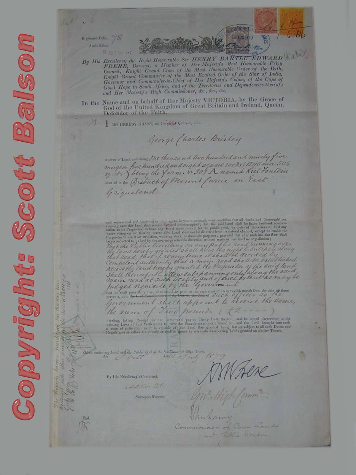
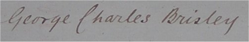
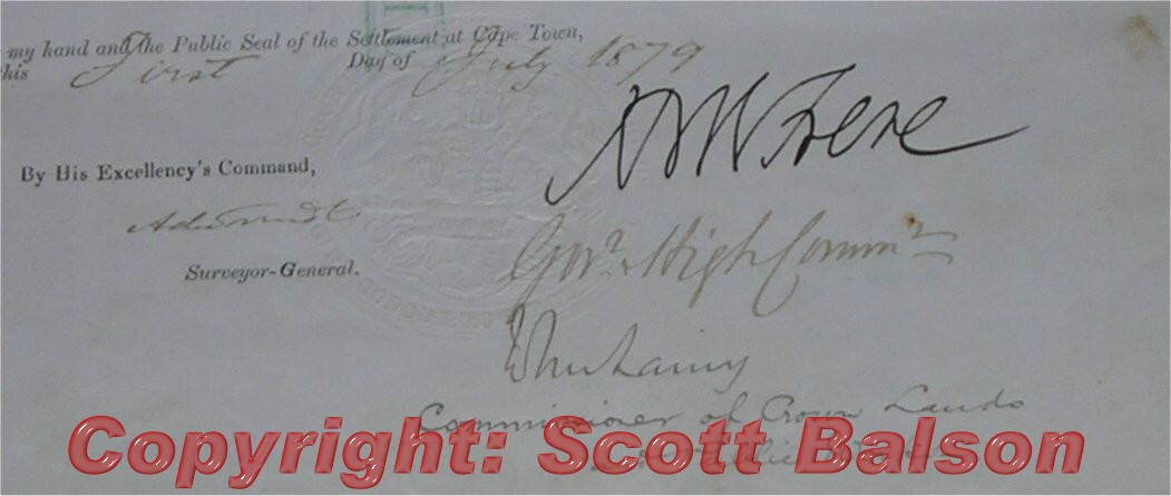
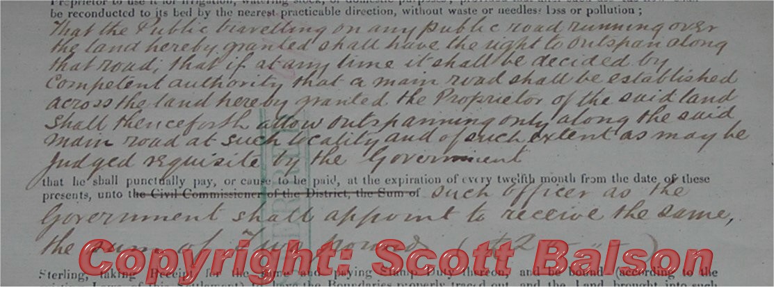
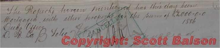
Property, Riet Fontein, purchased by George Charles Brisley 1st July 1879 - East Griqualand
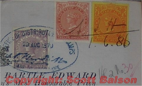
This Grant to Brisley on perpetual quitrent was authorised at Cape Town on 1st July 1879 and carries the official embossed "Public seal of the settlement at Cape Town". The Grant (full document on right) is signed by the Governor and High Commissioner, Sir Henry Bartle Frere and by the Commissioner of Crown Lands. The deed is for the farm "Rietfontein" which measures 1295 morgen in extent in the Mount Currie (Kokstad) district of East Griqualand. The deed has three revenue stamps, four pound, twelve shilling and three penny. The document is owned by the Balson Holdings Family Trust.
Brisley was the official who announced in 1872 that the name of the capital
of East Griqualand would be "Kokstad". Images below: key parts of the original land grant to Charles Brisley
|